"

2. Create a point vector

In this part, you will utilize the Marion.loc address locator we created to convert text-based address information to a vector file.

1. Add IMPD_UCR_Homiside_2011.csv

2. In your Contents pane, right-click on IMPD_UCR_Homiside_2011.csv and click Open. You will see the table that contains text-based information.

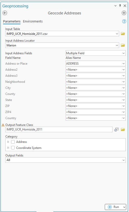
3. In the Geoprocessing tab, search for Geocode Addresses and open it.

4. Fill in the Geocode Addresses tool with IMPD_UCR_Homiside_2011.csv, Marion.loc, and IMPD_UCR_Momiside_2011 as an output feature class name. Click Run:

Screenshot of the Geoprocessing pane in ArcGIS Pro showing the “Geocode Addresses” tool. The Parameters tab is active. The Input Table is set to IMPD_UCR_Homicide_2011.csv, and the Input Address Locator is Marion. Below, the Input Address Fields section lists fields such as Address or Place, Address2, Address3, Neighborhood, City, County, State, ZIP, ZIP4, and Country, with most set to except Address or Place mapped to ADDRESS. The Output Feature Class is named IMPD_UCR_Homicide_2011. Additional options include Category (Address and Coordinate System) and Output Fields set to All. A Run button appears at the bottom right.
Geoprocessing pane in ArcGIS Pro showing the Geocode Addresses tool. The Parameters tab is active, with the input table set to IMPD_UCR_Homicide_2011.csv and the address locator set to Marion. Address fields are mapped, and the output feature class is named IMPD_UCR_Homicide_2011. Additional options include category settings and output fields, with a Run button at the bottom.

5. Repeat Geocode Addresses using IMPD_UCR_Homiside_2021.csv 

6. Change the symbology of your two outcomes to distinguish between the two vectors.

Figure 1 (1 pt.)

Submit two screenshots of the IMPD_UCR_Homiside_2011 and IMPD_UCR_Homiside_2021.


License

Intro GIS Labs Copyright © by yurikim. All Rights Reserved.