"

3. Rematch unmatched addresses

There might be (or “always”) errors in the geocoding output layer. You will confirm that the vector points layer you just created fits well with the already existing data, in this case, Basemap.

1. Right-click the IMPD_UCR_Homiside_2011 layer, find Data, and choose Rematch Addresses.

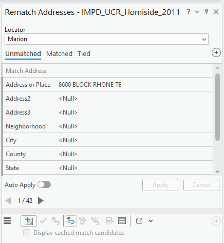
2. In the Rematch Addresses pane, we can find three categories: Matched, Unmatched, and Tied. For example, we can see 42 (or a slightly different number in your IMPD_UCR_Homiside_2011 layer) in the Unmatched section.

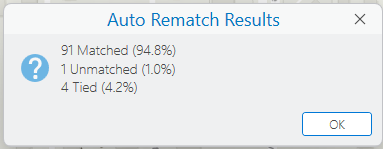
3. First, click the Auto Rematch icon (see the figure below) to edit the unmatched preliminarily:

Screenshot of the Rematch Addresses pane in ArcGIS Pro for the dataset IMPD_UCR_Homicide_2011. The Locator is set to Marion. The Unmatched tab is active, showing one record with the match address “8600 BLOCK RHONE TE.” Other fields such as Address2, Address3, Neighborhood, City, County, and State display . Auto Apply is toggled on, and navigation shows record 1 of 42. Apply and Cancel buttons are present but inactive.
Rematch Addresses pane in ArcGIS Pro showing unmatched addresses from the IMPD_UCR_Homicide_2011 dataset. The Locator is set to Marion, and the first unmatched record displays “8600 BLOCK RHONE TE” with other address fields listed as null. Navigation indicates record 1 of 42, with Auto Apply enabled and Apply/Cancel buttons inactive.

Then, the Auto Rematch Results message says it provides a more correct address-matching outcome:

Dialog box titled “Auto Rematch Results” in ArcGIS Pro. It displays three results: 91 Matched (94.8%), 1 Unmatched (1.0%), and 4 Tied (4.2%). An information icon appears on the left, and an OK button is located at the bottom right.
Auto Rematch Results dialog in ArcGIS Pro summarizes address-matching outcomes: 91 matched (94.8%), 1 unmatched (1.0%), and 4 tied (4.2%). An OK button is available to close the dialog.

4. Let’s edit the first unmatched address. Fill in the City, County, and State fields as we know them and click Apply. We can find multiple address points:

Screenshot of the Rematch Addresses pane in ArcGIS Pro for the dataset IMPD_UCR_Homicide_2011. The Locator is set to Marion, and the Unmatched tab is active. The match address is “2100 BLOCK N CAPITAL ALLEY EAST,” with City as Indianapolis, County as Marion, and State as IN; other fields show . Auto Apply is off. Below, a list of five candidate addresses is displayed with their type and score: two StreetMidBlock matches (80.43), one StreetAddress (75.59), another StreetMidBlock (75.33), and one StreetName (70.79). Apply and Cancel buttons are inactive.
Rematch Addresses pane in ArcGIS Pro showing an unmatched address from the IMPD_UCR_Homicide_2011 dataset. The address is “2100 BLOCK N CAPITAL ALLEY EAST” in Indianapolis, Marion County, Indiana. Below, five candidate matches are listed with their types and scores, including StreetMidBlock and StreetAddress options with scores ranging from 70.79 to 80.43.

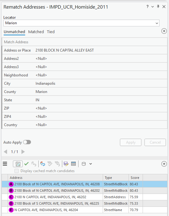
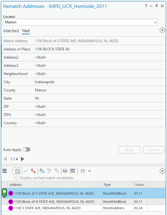
Stop and think: The score shows how much the original addresses from the spreadsheet (i.e., CSV file) match the suggested addresses. If you found identical scores in multiple optional addresses, like the figure above, you decide to make. You probably need more clues to finalize the location, such as visiting the site or getting information from people who know it well (e.g., police officers). For this exercise, let’s select the first address candidate as a trial.

5. Highlight the address point with the highest “score.” Click the Match icon —the green check mark.

The candidate automatically moves to the Matched category. Now we see two categories: Matched and Tied.

6. Click the Tied category. You might find four (or more, or fewer) candidates like the figure below:

Screenshot of the Rematch Addresses pane in ArcGIS Pro for the dataset IMPD_UCR_Homicide_2011. The Locator is set to Marion, and the Tied tab is active. The match address is “1100 Block of S STATE AVE, INDIANAPOLIS, IN, 46203,” while the original address or place is “1100 BLOCK STATE AV.” Other fields such as Address2, Address3, Neighborhood, City, County, State, ZIP, ZIP4, and Country display . Auto Apply is off. Apply and Cancel buttons are inactive. Navigation shows record 1 of 4, with options to display cached match candidates at the bottom.
Rematch Addresses pane in ArcGIS Pro showing a tied address match for the IMPD_UCR_Homicide_2011 dataset. The original address is “1100 BLOCK STATE AV,” and the matched candidate is “1100 Block of S STATE AVE, INDIANAPOLIS, IN, 46203.” Other address fields are null. Auto Apply is off, and Apply/Cancel buttons are inactive. Navigation indicates record 1 of 4 tied matches.

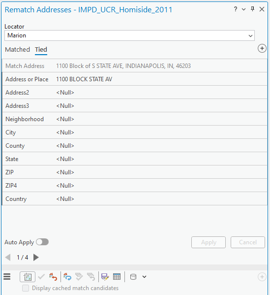
7. Again, fill in the City, County, and State fields as we know them and click Apply. We can find multiple address points:

Screenshot of the Rematch Addresses pane in ArcGIS Pro for the dataset IMPD_UCR_Homicide_2011. The Locator is set to Marion, and the Tied tab is active. The match address is “1100 Block of S STATE AVE, INDIANAPOLIS, IN, 46203,” and the original address or place is “1100 BLOCK STATE AV.” Additional fields show City as Indianapolis, County as Marion, and State as IN; other fields display . Auto Apply is off, and Apply/Cancel buttons are inactive. Navigation shows record 1 of 4. Below, three candidate addresses are listed with type and score: “1100 Block of S STATE AVE, INDIANAPOLIS, IN, 46203” (StreetMidBlock, 93.11), “1100 Block of N STATE AVE, INDIANAPOLIS, IN, 46201” (StreetMidBlock, 93.11), and “1100 S STATE AVE, INDIANAPOLIS, IN, 46203” (StreetAddress, 82.24).
Rematch Addresses pane in ArcGIS Pro showing a tied match for the IMPD_UCR_Homicide_2011 dataset. The original address is “1100 BLOCK STATE AV,” and the matched candidate is “1100 Block of S STATE AVE, INDIANAPOLIS, IN, 46203.” Additional fields show City as Indianapolis, County as Marion, and State as IN. Below, three candidate addresses are listed with their types and scores: two StreetMidBlock matches (93.11) and one StreetAddress match (82.24).

8. Choose one candidate and double-click it.

9. Repeat the entry for City, County, and State for all the tied addresses.

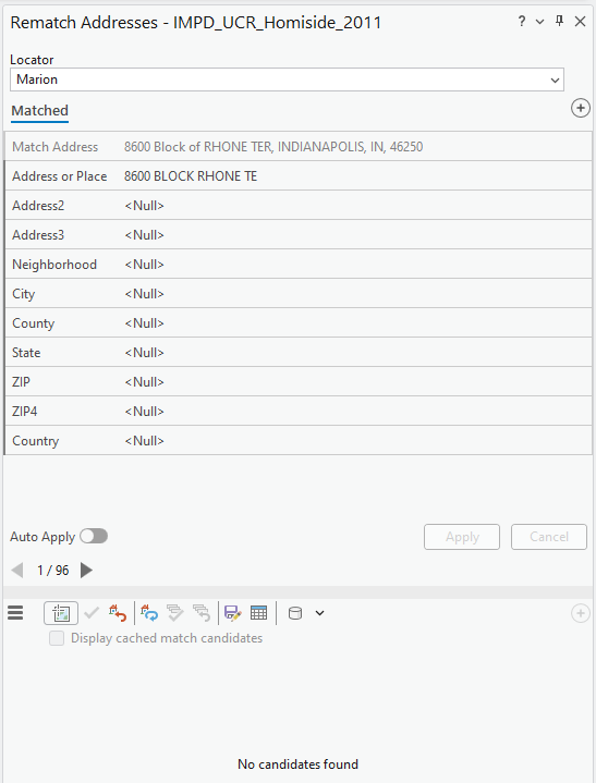
10. The final Rematch Addresses outcome will show us all addresses in the Matched category:

Screenshot of the Rematch Addresses pane in ArcGIS Pro for the dataset IMPD_UCR_Homicide_2011. The Locator is set to Marion, and the Matched tab is active. The match address is “8600 Block of RHONE TER, INDIANAPOLIS, IN, 46250,” and the original address or place is “8600 BLOCK RHONE TE.” All other fields, including Address2, Address3, Neighborhood, City, County, State, ZIP, ZIP4, and Country, display . Auto Apply is off, Apply and Cancel buttons are inactive. Navigation shows record 1 of 96. At the bottom, a message reads “No candidates found.”
Rematch Addresses pane in ArcGIS Pro showing a matched address for the IMPD_UCR_Homicide_2011 dataset. The original address is “8600 BLOCK RHONE TE,” and the matched candidate is “8600 Block of RHONE TER, INDIANAPOLIS, IN, 46250.” Other address fields are null. Auto Apply is off, Apply/Cancel buttons are inactive, and navigation indicates record 1 of 96. The bottom section displays “No candidates found.”

11. Repeat the rematch process with the IMPD_UCR_Homiside_2021 layer

Figure 2 (1 pt.)

Submit two screenshots of the final Rematch Addresses outcome of IMPD_UCR_Homiside_2011 and IMPD_UCR_Homiside_2021, like the figure above.


License

Intro GIS Labs Copyright © by yurikim. All Rights Reserved.