"

Add data in ArcGIS Pro

1. Please double-check if the Lab 1 data is ready to be displayed in ArcGIS Pro. To do this, download “Lab01_data.zip” from Canvas and unzip it.


Screenshot of the "Map" tab in a GIS software interface. The toolbar includes sections for Clipboard (Paste, Cut, Copy, Copy Path), Navigate (Explore, Zoom In/Out, Pan, Full Extent, Previous/Next Extent), Bookmarks, Go To XY, Basemap, and Layer (Add Data). The top menu bar displays tabs: Project, Map (selected), Insert, Analysis, View, Edit, Imagery, Share, and Help.
The “Map” tab in ArcGIS Pro, highlighting essential tools for navigation, data management, and basemap selection.

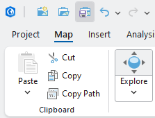
2. On the ribbon, on the Map tab, in the Layer group, click the Add Data button:

3. In the Add Data window, click Data and find your lab01 data folder, which you previously unzipped from lab01.zip. You can find one geodatabase file (usa_geog.gdb) and three shapefiles (US_counties.shp, US_rivers.shp, and US_roads.shp), which are in “vector” format: Screenshot of the "Add Data" window in ArcGIS software. The left pane displays a folder structure with options like Project, Databases, Folders (selected), and Portal. The right pane lists four geospatial files in the "Lab01_data" folder: "usa_geog.gdb" (File Geodatabase), "US_counties.shp" (Polygon Shapefile), "US_rivers.shp" and "US_roads.shp" (Line Shapefiles). At the bottom are fields for entering a name and selecting a type from a dropdown menu labeled "Default," with OK and Cancel buttons in the bottom right corner.

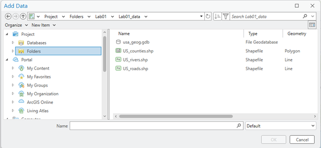
4. Add three shapefiles to your ArcGIS Pro:

Screenshot of a GIS software interface displaying a map of the United States with green state boundaries, major roads, and rivers. The map also includes portions of Canada and Mexico. The left panel titled "Contents" lists map layers in drawing order: "US_roads," "US_rivers," and "states_poly."
A map of the United States displaying state boundaries in green and county divisions within each state. The Great Lakes are highlighted in pink. The map layers shown in the Contents pane include “state_poly” and “US_Counties,” illustrating how multiple geographic datasets can be visualized simultaneously in ArcGIS Pro.


Stop and check: Your ArcGIS Pro might not look the same as the screenshots in the instructions.

5. This time, you will add state_poly.shp in usa_geo.gdb. Click the Add Data button again, then double-click usa_geo.gdb: Screenshot of the "Add Data" window in GIS software. The top displays the directory path: G338 > Labs > Lab01 > Lab01_data > usa_geog.gdb. The main pane lists three geospatial items: "states_line" (Line, File Geodatabase), "states_poly" (Polygon, File Geodatabase), and "states_zzzzzz" (Line, File Geodatabase). The left pane shows a navigation tree with sections like Databases, Folders, Portal (including My Content and My Favorites), and Computer. At the bottom are fields for entering a name and selecting a type from a dropdown menu labeled "Default," with OK and Cancel buttons in the bottom right corner.

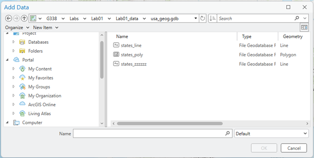
6. Now you have found that usa_geo.gdb contains three layers. Click state_poly, then click OK: 

Screenshot of a GIS software interface displaying a map of the United States with green state boundaries, major roads, and rivers. The map also includes portions of Canada and Mexico. The left panel titled "Contents" lists map layers in drawing order: "US_roads," "US_rivers," and "states_poly."
A map of the United States displaying state boundaries in green and county divisions within each state. The Great Lakes are highlighted in pink. The map layers shown in the Contents pane include “state_poly” and “US_Counties,” illustrating how multiple geographic datasets can be visualized simultaneously in ArcGIS Pro.

Click Save to keep your current ArcGIS view. Click this button frequently to avoid losing your work!:

Screenshot of a GIS software interface showing a toolbar with icons for Save, Undo, and Redo. Below the toolbar are menu tabs: Project, Map (selected), Insert, and Analysis. The Map tab displays clipboard options including Paste (with dropdown), Cut (scissors icon), Copy (two documents icon), Copy Path (clipboard icon), and an Explore button with directional arrows.

Further study: How does ArcGIS manage the GIS database? 

It is essential to understand that ArcGIS manages geospatial data in ways Windows does not understand. To demonstrate this, let’s open Windows File Explorer and navigate to your lab01 data folder:

Screenshot of a file explorer window displaying the contents of the "Lab01_data" folder. The folder includes geographic data files related to US counties, such as "usa_geog.gdb" and multiple files with extensions like .cpg, .dbf, .prj, .sbn, .sbx, .shp, and .lock. The selected file is "US_counties.shp," with a size of 126,488 KB.

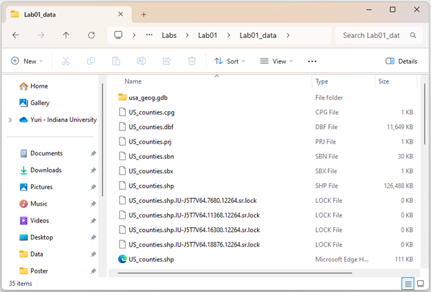
Wait! You just found three shapefiles in ArcGIS: US_counties.shp, US_rivers.shp, and US_roads.shp (Let’s talk about the .gdb file a little later). However, there are important observations to note in Windows File Explorer:

  • ArcGIS shows only one feature named shp. The Windows File Explorer shows seven files of various types with US_counties as their root name. All seven files in Windows comprise a single GIS feature in ArcGIS.
  • None of the icons that Windows File Explorer uses for the files match the icon used by ArcGIS for that feature.
  • Windows File Explorer also shows two files named shp, but with different icons and types: one is listed as an “SHP file,” and the other is listed as an “XML Document” file.
  • ArcGIS displays a file geodatabase named gdb, indicated by an icon. The Windows File Explorer shows a directory “folder” called usa_geog.gdb.

Now, double-click usa_geog.gdb folder in the Windows File Explorer:

Screenshot of a file explorer window displaying the contents of the "usa_geog.gdb" folder, located under "Lab01 > Lab01_data > usa_geog.gdb." The right pane lists various GIS-related files with extensions such as .lock, .gdbindexes, .gdbtable, .gdbtablx, .horizon, .spx, and .freelist. File types include LOCK File, GDBINDEXES File, GDBTABLE File, GDBTABLX File, HORIZON File, SPX File, and FREELIST File, with sizes ranging from 0 KB to 464 KB.

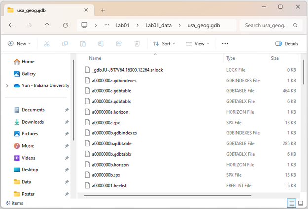
Wow!  We identified three data features (states_poly, states_line, and states_zzzzzz) on the ArcGIS software. However, Windows File Explorer displays a lot of code that we cannot understand. None of the files presented by Windows File Explorer in the .gdb directory contain names related to states_polystates_line, or states_zzzzzz. Together in the directory, all these files are understood and managed by ArcGIS to represent the file geodatabase and its three data features.

Stop and emphasize: An important takeaway is that we allow ArcGIS to manage the files necessary for your GIS work, not Windows File Explorer!

Question 1 (0.5 pts.)

Explain how GIS data looks different in ArcGIS vs. Windows File Explorer.


License

Intro GIS Labs Copyright © by yurikim. All Rights Reserved.