
1. XY Coordinate to Point Vector
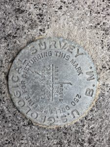
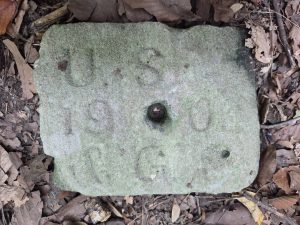
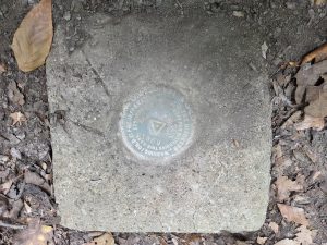
Benchmarks in IU Bloomington
As we recall our “Coordinate & Projection” week of learning, the shape of our Earth is described by datums, such as NAD83 and WGS84. Benchmarks are elements of the datum, which show its location using latitude and longitude. There are around 740,000 benchmarks in the US, and the National Geodetic Survey (NGS) provides the location of benchmarks in the US: https://www.arcgis.com/apps/webappviewer/index.html?id=190385f9aadb4cf1b0dd8759893032db
In this lab, we will find the three benchmarks on the IUB campus that we will create a point vector layer and find with GPS:
- 1st marker = 39.16694 N, 86.52556 W (or 39.16694, -86.52556)
- 2nd marker = 39.16600 N, 86.52468 W
- 3rd marker = 39.16592 N, 86.52446 W (Heads-up: This one could be tricky to find!)
Create a point vector layer using XY coordinates.
1. Create a CSV file containing the coordinates for each survey marker. To do this, you need to put the XY data into Excel with three headers (Marker_ID, X_coord, Y_coord) and then save it into a CSV (comma-delimited) file:
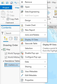
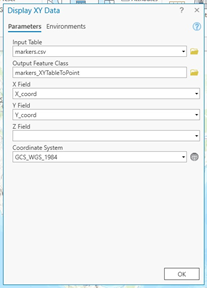
2. Add the above CVS file to ArcGIS Pro. In the Contents pane, right-click on your CVS file > Display XY Data. Then click OK:
Stop and Remind: Remember that latitude is preceded by a minus sign (–) if the location is in the southern hemisphere and a positive number in the northern hemisphere. Longitude is preceded by a minus sign (-) if it is west of the prime meridian, and a positive number means east. For the benchmark location, you need to convert your “West” coordinates to negative numbers in Excel before adding them to ArcGIS. For example, 86.5454° W should be -86.5454 in the CSV format.
Figure (1 pt.)
Make a map of three benchmarks using “Imagery Hybrid” as your base map.