
1. Process Raster with Vector (1): Extract by Mask & Data Conversion
First, we will extract Monroe County’s census tract-level land use/land cover from the National Land Cover Dataset (NLCD) 2024. What kind of “tool” are we going to choose from the Geoprocessing tab in ArcGIS Pro? Here is a complication regarding GIS process; as we are dealing with both vector (e.g., Monroe County census tract) and raster (e.g., National Land Cover Dataset) sources, the “Clip” tool in the Geoprocessing tab (reminder: The Clip tool in ArcGIS Pro mainly acts like a “cookie cutter” in VECTOR formats) could lead us to processing error. We will use the Extract by Mask tool to clip raster data with a vector polygon.
1. Add NLCD2024_UTM.img and Monroe_BlockGroup_2025_UTM
2. Using Symbology, remove the default color of the Monroe_Block_Group_2025 layer so we can see the NLCD data inside Monroe County.
3. In the Geoprocessing, search for Extract by Mask and fill in the Parameters like:
-
- Input raster: NLCD2024_UTM.img
- Input raster or feature mask data: Monroe_BlockGroup_2025_UTM
- Output raster: NLCD2024_Monroe
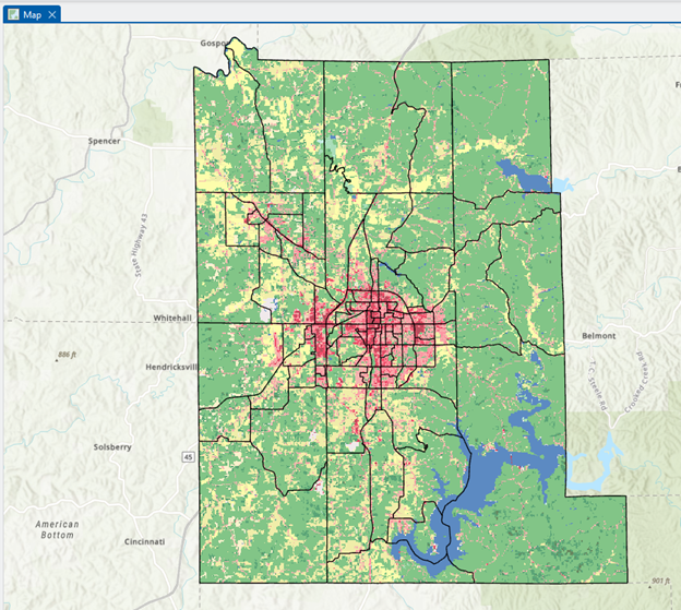
4. Click Run. Your outcome looks like the figure below:
The next geoprocessing step is data conversion. Although modern GIS systems can manage raster and vector data, it is often necessary to transform one data model into another. In this case, we will convert raster to vector – i.e., raster format (.tiff) NLCD data to the polygon vector.
4. In the Geoprocessing, search for Raster to Polygon and fill in the parameters like:
-
- Input raster: NLCD2024_Monroe
- Field: ClassName
- Output polygon features: NLCD2024_polygon
- And UNCHECK the Simplify polygons
5. Click Run
Stop and compare: Uncheck “Simplify polygons.” If it is checked, the edges of the polygon become smoother, and the unchecked option will make the polygon edges the same as the input raster’s cell.
Figure (1 pt.)
Zoom in on some location and make two screenshots of the “Simplified” and “Unsimplified” Raster to Polygon conversion outcomes.