
Part One: Fundamentals of Environmental Geology
Lab 2 Reading: Plate Tectonics
Plate Tectonics
Introduction
In chapter one, we reviewed the scientific method and the exact meaning of a theory, which is a well-supported explanation for a natural phenomenon that still cannot be completely proven. A Grand Unifying Theory is a set of ideas that is central and essential to a field of study such as the theory of gravity in physics or the theory of evolution in biology. The Grand Unifying Theory of geology is the theory of Plate Tectonics, which defines the outer portion of the earth as a brit- tle outer layer that is broken into moving pieces called tectonic plates. This the- ory is supported by many lines of evidence including the shape of the continents, the distribution of fossils and rocks, the distribution of environmental indicators, as well as the location of mountains, volcanoes, trenches, and earthquakes. The movement of plates can be observed on human timescales and easily measured using GPS satellites.
Plate tectonics is integral to the study of geology because it aids in reconstruct- ing earth’s history. This theory helps to explain how the first continents were built, how oceans formed, and even helps inform hypotheses for the origin of life. The theory also helps explain the geographic distribution of geologic features such as mountains, volcanoes, rift valleys, and trenches. Finally, it helps us assess the po- tential risks of geologic catastrophes such as earthquakes and volcanoes across the earth. The power of this theory lies in its ability to create testable hypotheses regarding Earth’s history as well as predictions regarding its future.
Learning Outcomes
After completing this chapter, you should be able to:
- Explain several lines of evidence supporting the movement of tectonic plates
- Accurately describe the movement of tectonic plates through time
- Describe the progression of a Hawaiian Island and how it relates to the Theory of Plate Tectonics
- Describe the properties of tectonics plates and how that relates to the proposed mechanisms driving plate tectonics
- Be able to describe and identify the features that occur at different plate boundaries
Key Terms
- Continental Crust
- Convergent Boundary
- Divergent Boundary
- Grand Unifying Theory
- Hot Spot
- Oceanic Crust
- Ridge Push
- Slab Pull
- Slab Suction
- Subduction
- Tectonic plates
- Theory of Plate Tectonics
- Transform Boundary
- Wadati-Benioff Zone
EVIDENCE OF THE MOVEMENT OF CONTINENTS
The idea that the continents appear to have been joined based on their shapes is not new, in fact this idea first appeared in the writings of Sir Francis Bacon in 1620. The resulting hypothesis from this observation is rather straightforward: the shapes of the continents fit together because they were once connected and have since bro- ken apart and moved. This hypothesis is discussing a historical event in the past and cannot be directly tested without a time machine. Therefore, geoscientists reframed the hypothesis by assuming the continents used to be connected and asking what other patterns we would expect to find. This is exactly how turn of the century earth scientists (such as Alfred Wegener) addressed this important scientific question.
Wegener compiled rock types, fossil occurrences, and environmental indicators within the rock record on different continents (focusing on Africa and South Amer- ica) that appear to have been joined in the past and found remarkable similarities. Other scientists followed suit and the scientific community was able to compile an extensive dataset that indicated that the continents were linked in the past in a supercontinent called Pangaea (coined by Alfred Wegener) and have shifted to their current position over time. Dating these rocks using the methods discussed in chapter one allowed the scientists to better understand the rate of motion, which has assisted in trying to determine the mechanisms that drive plate tectonics.
Plate Motion and Evidence
As was mentioned above one of the most striking things about the geography of the continents today is how they appear to fit together like puzzle pieces. The reason for this is clear: they once were connected in the past and have since sepa-rated shifting into their current positions. Open Google Earth and zoom out to an eye altitude of ~8000 miles. Examine the coastlines of eastern South America and Western Africa and notice how well they match in shape.
There are scientifically important rock deposits in southern Brazil, South America and Angola, Africa that show the northernmost glacial deposits on the ancient continent of Pangaea, which indicates these two areas were once connect-ed.
Hot Spots
Another line of evidence that can be used to track plate motion is the location of hot spots. Hot spots are volcanically active areas on the Earth’s surface that are caused by anomalously hot mantle rocks underneath. This heat is the result of a mantle plume that rises from deep in the mantle toward the surface resulting in melted rocks and volcanoes. These mantle plumes occur deep in the Earth such that they are unaffected by the movement of the continents or the crust under the ocean. Mantle plumes appear to be stationary through time, but as the tectonic plate moves over the hot spot a series of volcanoes are produced. This gives geol- ogists a wonderful view of the movement of a plate through time with the distri- bution of volcanoes indicating the direction of motion and their ages revealing the rate at which the plate was moving.
One of the most striking examples of a hot spot is underneath Hawaii. The mantle plume generates heat that results in an active volcano on the surface of the crust. Each eruption causes the volcano to grow until it eventually breaks the surface of the ocean and forms an island. As the crust shifts the volcano off the hot spot the volcano loses its heat and become inactive. The volcano then cools down, contracts, erodes, sinks slowly beneath the ocean surface, and is carried by the tec-tonic plate as it moves through time. As each island moves away from the mantle plume a new island will then be formed at the hot spot in a continual conveyor belt of islands. Therefore, the scars of ancient islands near Hawaii give a wonderful view of the movement of the tectonic plate beneath the Pacific Ocean.
Plate Materials
By now you can see many different lines of evidence that the tectonic plates are moving (there are many additional lines of evidence as well). To build a theory we need an explanation or a mechanism that explains the patterns that we see. The the- ory of plate tectonics states that the outer rigid layer of the earth (the lithosphere) is broken into pieces called tectonic plates (Figure 4.3) and that these plates move independently above the flowing plastic-like portion of the mantle (Asthenosphere).
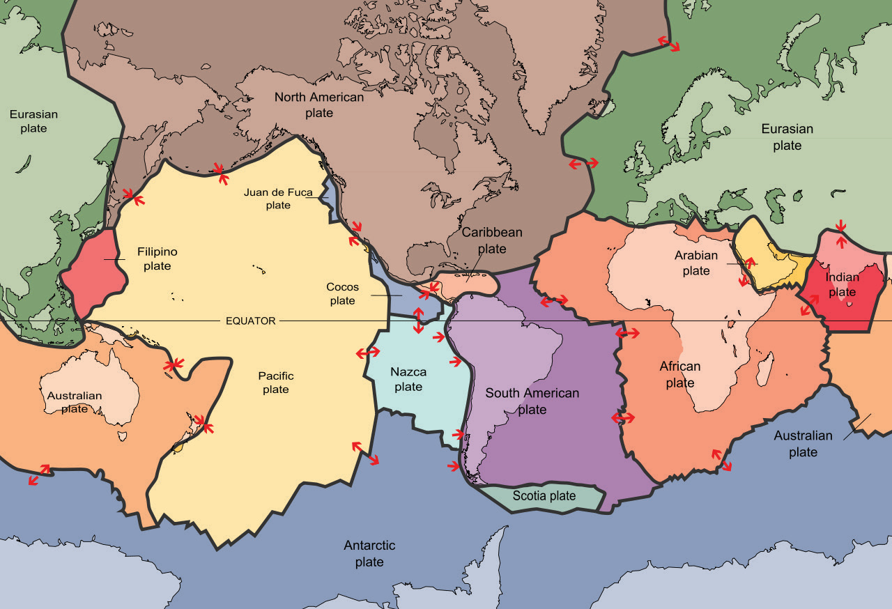
Figure 4.3 | Tectonic plates on Earth.
Author: USGS Source: USGS License: Public Domain
Tectonic plates are composed of the crust and the upper most mantle that functions as a brittle solid. These plates can be composed of oceanic crust, continental crust or a mixture of both. The Oceanic Crust is thinner and normally underlies the world’s oceans, while the Continental Crust is thicker and like its name consists of the continents. The interaction of these tectonic plates is at the root of many geologic events and features, such that we need to understand the structure of the plates to better understand how they interact. The interaction of these plates is controlled by the relative motion of two plates (moving together, apart, or sliding past) as well as the composition of the crustal portion of the plate (continental or ocean crust). Continental crust has an overall composition similar to the igneous rock granite, which is a solid, silica-rich crystalline rock typically consisting of a mixture of pink (feldspar), milky white (feldspar), clear (quartz), and black (biotite) minerals. Oceanic crust is primarily composed of the igneous rock gabbro, which is a solid, iron and magnesium-rich crystalline rock consisting of a mixture of black and dark gray minerals (pyroxene and feldspar). The difference in rock composition results in distinctive physical properties that you will determine in the next set of questions.
Plate Densities
An important property of geological plates is their density (mass/volume). Remember the asthenosphere has fluid-like properties, such that tectonic plates ‘float’ relative to their density. This property is called isostasy and is similar to buoyancy in water. For example, if a cargo ship has a full load of goods it will appear lower than if it were empty because the density of the ship is on average higher. Therefore, the relative density of two plates can control how they interact at a boundary and the types of geological features found along the border between the two plates. Measuring the density of rocks is fairly easy and can be done by first weighing the rocks and then calculating their volume. The latter is best done by a method called fluid displacement using a graduated cylinder. Water is added to the cylinder and the level is recorded, a rock is then added to the cylinder and the difference in water levels equals the volume of the rock. Density is then calculated as the mass divided by the volume (Figure 4.4).
The information needed to calculate density was collected for four rocks and can be used to answer the following questions including the weight (in grams) as well as
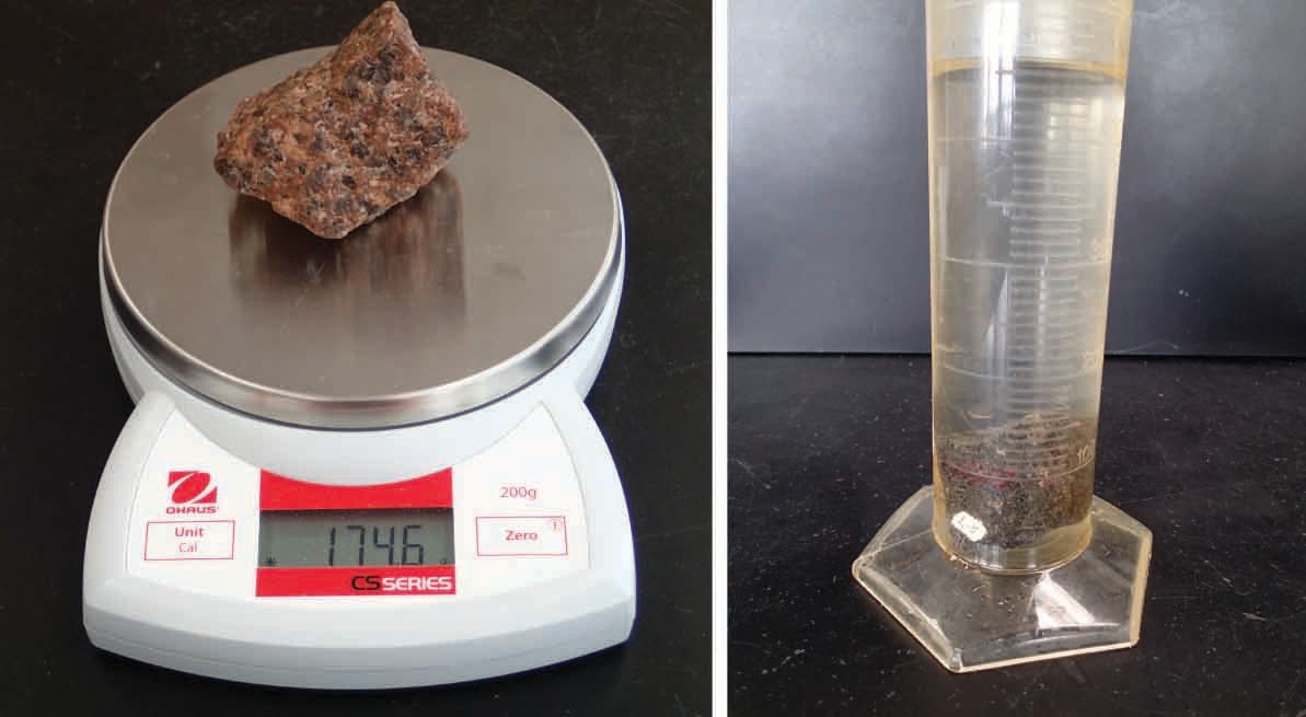
Figure 4.4 | Method to find the density of a rock. First the weight is measured on a digital scale and then the fluid displacement method is used to determine the volume.
Author: Bradley Deline Source: Original Work License: CC BY-SA 3.0
the volume of water recorded by a graduated cylinder (in milliliters) before and after the rock was added. Note: each line on the graduated cylinder represents 10 ml. When measuring the volume please round to the nearest 10 milliliter line on the graduated cylinder. Hint: Surface tension will often cause the water level to curve up near the edges of the graduated cylinder creating a feature called a meniscus. To ac- curately measure the volume, use the lowest point the water looks to occupy.
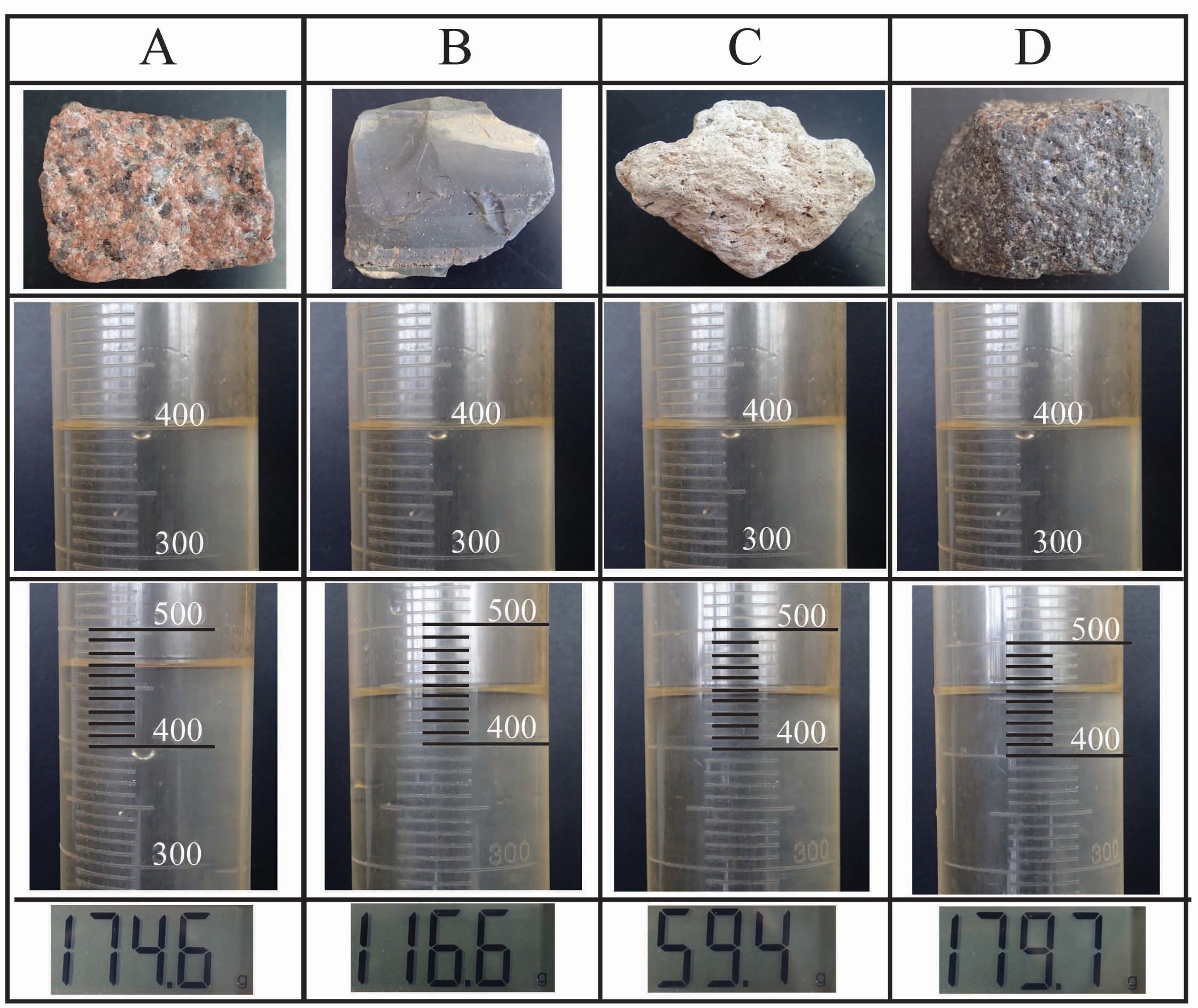
Figure 4.5 | Figure to use to answer questions 15-19.The first row shows images of the four rocks. The second and third rows show the volume (in milliliters) of material in the graduated cylinder before and after the rock was added. The last row shows the mass (in grams) of the four rocks.
Author: Bradley Deline Source: Original Work License: CC BY-SA 3.0
Plate Boundaries
Tectonic plates can interact in three different ways they can come together, they can pull apart, or they can slide by each other (Figure 4.6). The other fac- tor that can be important is the composition of the plates (oceanic or continental crust) that are interacting as was explored in the previous section. These three types of motions along with the type of plates on each side of the boundary can produce vastly different structures and geologic events (Table 4.1).
Two plates that are moving apart from each other are called Divergent. Divergent boundaries are important because they are the way that continents split apart and break into separate plates as well as where new ocean crust is formed. If a divergent boundary forms within a continent that area stretches apart. This results in the area becoming thinner creating a topographic low or a valley. This extension is not a smooth process so the area is prone to earthquakes as well as volcanic activity. Eventually, the crust gets so thin it will rupture forming a gap be- tween the plates, which will be filled with molten rock forming new oceanic crust. A thin and dense plate will be topographically low and will be covered in water forming a long and narrow sea. As the plates persist in pulling apart new crust is continually being formed at the plate boundary along an elevated crest known as a mid-oceanic ridge.
Two plates that are moving together are called Convergent. Convergent boundaries are important because they are the way distinctive plates can join (suture) together to form larger plates as well as where ocean crust is destroyed. The resulting structures we see at convergent boundaries depend on the types of tectonic plates. If two thick and lower density continental plates converge we get a large collision which results in mountains. This is a violent process resulting in many earthquakes, deformation (folds and faults) of rock, and the uplift of moun- tains. The rocks are also under immense pressure and heat and will eventually
become stuck together as a single plate. If a continental plate and an ocean plate converge (continent-ocean convergent plate boundary) there will be subduction, where the oceanic plate sinks downward underneath the continental plate. This will result in several features including a deep trench near the subducting plate, abundant earthquakes, and the formation of magma which results in a line of vol- canoes along the coast. Associated with this type of plate boundary is the Wa- dati–Benioff zone, a zone where earthquakes are produced; this zone ranges in depth from shallow (at the trench) to deep (~600km), indicating that the oceanic plate is sinking into the mantle. If two oceanic plates converge it will also result in subduction with similar features as were just discussed. The only exception will be that the volcanoes will appear on an oceanic plate and will eventually form islands along the tectonic boundary.
When the two plates slide past each other it is called a Transform bound- ary. This type of boundary differs from the previous two in that no new crust is being formed and no old crust is being destroyed. Therefore, there won’t be as many striking geologic features. Transform boundaries are often marked by abun- dant earthquakes that can be close to the surface as well as distinctive patterns of rivers that become offset as the land is moving underneath them. Transform boundaries are also often associated with mid-oceanic ridges. If a the ridge has a jagged or stair-stepped edge the pulling apart of the two tectonic plates will also result in transform motion as you can see in Figure 4.6.
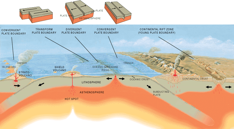
Figure 4.6 | Figure showing multiple plate boundaries and the features associated with them.
Author: José F. Vigil Source: USGS License: Public
Table 4.1. Characteristics of the different Plate Boundaries
|
Boundary Type |
Plate Compositions |
Earthquake Depth |
Change in Crust |
Identifying Features |
|
Divergent |
|
|
|
|
|
|
Continent- Continent |
Shallow |
No change |
Rift Valley and Volcanoes |
|
|
Ocean-Ocean |
Shallow |
Formation of New Crust |
Ocean Ridges |
|
Convergent |
|
|
|
|
|
|
Continent- |
|
|
|
|
|
Continent Continent- |
Shallow to Intermediate |
Metamorphism of Crust |
Mountains |
|
|
Ocean |
Shallow to Deep |
Melting of Crust |
Trench and Coastal Volcanoes |
|
Transform |
Ocean-Ocean |
Shallow To Deep |
Melting of Crust |
Trench and Volcanic Islands |
|
|
Continent- Continent |
Shallow |
No change |
Offset rivers |
|
|
Ocean-Ocean |
Shallow |
No change |
Often associated with Ocean ridges. |
Origin of Magma
Magma is formed from the melting of rock at both convergent and divergent boundaries. However, the processes that occur to melt the rock are quite different. Three different processes are involved in the melting of rocks as we will explore in the following exercise. In Figure 4.7 you can see a graph depicting a variety of temperature and pressure conditions. The increasing temperature with pressure on rocks as you go deeper within the earth through the crust and mantle lithosphere is called the geothermal gradient (shown in black). This gradient shows the actual temperature conditions that exist in the lithosphere. Obviously, the addition or subtraction of heat or pressure can move rocks off that gradient and cause potential change. The orange line represents the temperature and pressure required for a dry mantle rock to start to melt and any point to the right of this line is where melting of lithospheric rock can occur. The blue line represents the temperature and pressure required for a lithospheric rock to melt if water is present.

Figure 4.7 | Melting diagram for mantle rock.
Author: Bradley Deline Source: Original Work License: CC BY-SA 3.0
Boundaries
Earthquakes are great indicators of plate boundaries and are associated with all three boundary types. One type of boundary is unique in having a Wadati-Benioff zone. Answer the following questions using Figure 4.8.
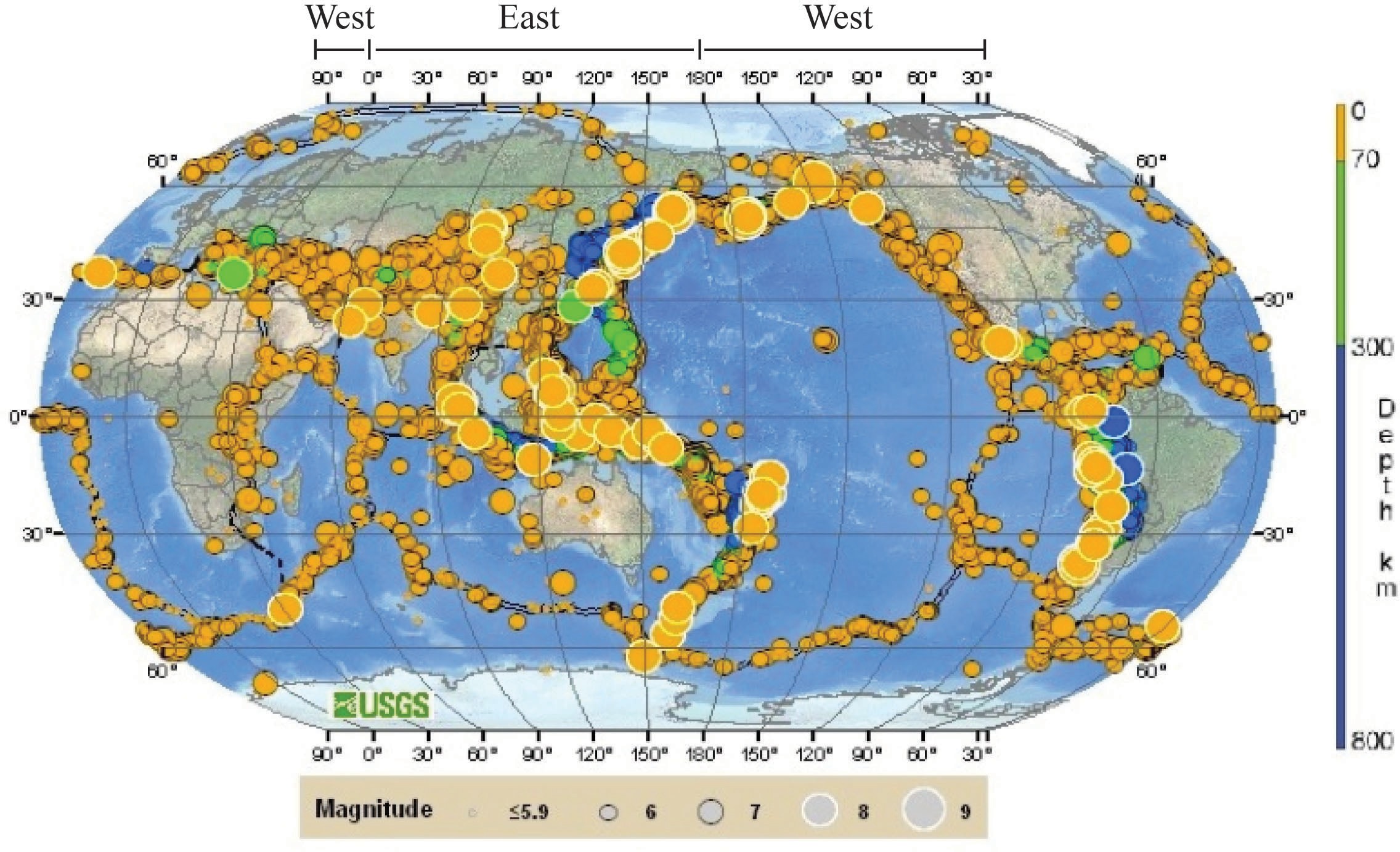
Figure 4.8 | Distribution and depth of Earthquakes.
Author: USGS Source: USGS License: Public Domain
PLATE TECTONIC MECHANISMS
The question still remains, why do tectonic plates move? The answer comes down to gravity and mantle convection. You have already studied in chapter two how the mantle flows through time creating convection currents. These convection currents flow underneath the plates and through friction pull them along at the surface as well as when they are subducted which is a force called slab suction. Related to this force is slab pull, which is a gravitational force pulling the cold subducting plate down into the mantle at a subduction zone. In addition, there is a force from potential energy at ocean ridges called ridge push. This is a gravitational force pushing down on the elevated ridge and because of the plates curvature it results in a horizontal force pushing the plate along the earth’s surface. These forces all occur deep inside the Earth and operate on very large geographic scales making them difficult to measure. There are several competing models for the mechanisms behind plate motion, such that there are still some areas of debate surrounding the mechanics of plate tectonics which is why Plate Tectonics is a scientific theory. Documenting an event is much easier and more straightforward than explaining why it occurred.

Feedback/Errata