
57 Climbing Mount Wilhelm
I climbed Mount Wilhelm over Easter, 1998. When Lae Explorers announced that they were leading an excursion up the tallest peak in Papua New Guinea, altitude14793 feet, I decided to be part of this expedition. It provided an opportunity to see a new part of PNG and would add to my teaching-research data base of slides and general information. I was interested in the PNG alpine vegetation of this mountain for comparative purposes with the 6000 feet alpine vegetation along Huon Gulf Coast in Lababia. There was also the personal challenge of climbing the highest peak in Papua New Guinea.
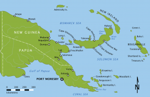
Papua New Guinea by spoolWhippits cco 1.0 creative commons 2020 Public Domain.
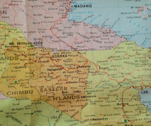 Central Papua New Guinea, Mt Wilhelm in left center of map. Papua New Guinea Tourist Map made by Gregory’s Publishing Company, Macquarie Park, New South Wales 2000.
The convoy of 4-wheel drive vehicles leaves Lae at 5 AM, Good Friday and in typical “Lae Explorer fashion,” drives “like hell” to get there. Unfortunately, I slow down the progress. We proceed through the colliding tectonic plate boundary that forms the broad Markham Valley and as day breaks, we begin our ascent from 1500 feet up Kassim Pass to 4000. The 60º F temperature is refreshing.
We stop for a short break at Yonke dam (source of electricity for Lae) before continuing along the winding road through Kainantu and Goroka. Refueling at Goroka, we head up Daulo Pass at 8000 feet enjoying the beautiful view looking back at Goroka. Roadside vendors selling strings of passion fruit entice us to stop.
At Kundiawa we turn off the asphalt sealed road and head north into 4-wheel drive country. Once we leave Kundiawa, the people become very friendly and wave and smile at our convoy. A hand wave or smile from us produces a joyful shout and the charming Chimbu smiles spread across their broad cheeks. We are now in the heart of Chimbu country; small compact huts dot the steep hillsides and occasionally cluster along the road.
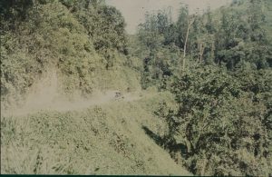 Canyon road in Papua New Guinea. Photo by Rick Bein 1998,
Traveling up a narrow stream valley, we cross several iron bridges covered with logs serving as planks. We finally come to one with board planks and the local villagers decide that they deserved to benefit from this fine bridge and demand money. Our group leader tells them “This is a government bridge” and the police have been called over the radio! The villagers removed the branches that blocked the roadway over the bridge.
The one lane road gradually ascends the canyon walls, and the steep cliffs cause some of us to hold our breath until we cross over into another watershed. The ruts make for a rough and twisting ride, but the vehicles are well designed, and we continue upward.
At 3 PM we reach the air strip at the village of Gembogl and in a few minutes we are at Betty Higgins’ guest house, trout and rabbit farm. Betty is a successful businesswoman who sells fish and vegetables in addition to earning money from the guest house. The meals include locally produced rainbow trout, cabbages, broccoli, carrots and strawberries.
At 7500 feet it is cool, something I have not experienced for a couple of years. The vegetation is a montane cloud forest with thick bluish looking trees rarely over 20 feet high. Epiphytes all but cover some of the trees and moss grows everywhere. The air is thin and after walking briskly through the gardens and between trout ponds I find myself out of breath.
The guest house is the starting point for the climb up Mount Wilhelm. Climbers spend the night here and the next morning walk to the “hut” at the base of the steep part of the mountain. Betty Higgins arranged for locals to carry our climbers’ food, clothes and sleeping bags to the huts and she contracted guides to lead the climbers up the mountain on the following day.
Rafael is my guide who also serves as a porter to carry my backpack with altimeter and Global Positioning System (GPS). He is in his early fifties and has climbed the mountain hundreds of times. His face looks 65 extremely weathered and having only a few teeth! Rafael is very knowledgeable about nature and points out many things and answers many questions. We carry on quite well in Tok-Pigeon but the talking slows us down to a pace that I can handle.
 Rafael my guide and me. Photo by Rick Bein 1998.
There is no agriculture above the guest house, and we see no one except porters and other climbers on the trail. The trail to the hut takes us through the moss forest to a broad glacial valley with a stream meandering through thick organic soils. Only one kind of stunted tree is scattered over the poorly drained valley floor; Rafael calls them “bumba” trees. The valley walls contain the classic glacial features of “truncated spurs” and “hanging valleys”. It is amazing to see the remains of the last ice age at only six degrees south of the equator.
After three hours we reach the hut at 10,000 feet. We put on more cloths. It shares the valley bottom with a beautiful glacial lake. Other glacial features loom above and the high “cirque basin’ and “arête” block our view of Mount Wilhelm. Rafael calls the lake “Laik Meri” and tells me about another “tarn” lake 1500 feet upstream which he calls “Laik Man”. (These are not the formal names of the lakes.) We rest here for the afternoon and into the evening acclimatizing to the high elevation.
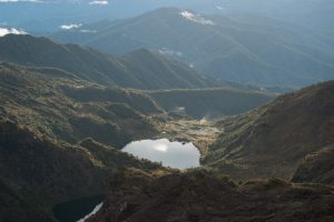 Cirque Lake, Hiking Mount Wilhelm by Lomacar is marked with CC BY-NC 2.0.
We go to bed early and sleep until 1 AM. We begin the steep climb bringing out our flashlights as we follow our guides. We are fortunate to have a full moon which is extra bright at this altitude, and except where we are in the shadows a flashlight is unnecessary. We plod along, resting every five hundred feet to catch our breath in the thin air. Working our way up the mountain our bodies build up heat keeping us warm, but when we stop for any length of time the perspiration begins to evaporate and we chill quickly. Hypothermia is a problem. By removing and adding layers of clothing damp from perspiration and adding dry layers we adjust for the cold.
Our group begins to split up as the more athletic surge on ahead and, Chris, the Frenchman, and I take up the rear. Mike, who normally runs several miles a day goes on ahead, is challenged by his twenty-year-old Chimbu guide. Seonaid is not far behind Mike, once she unloads her heavy winter coat for Rafael to squeeze into his backpack. Another person decides to go back to the hut after two hours. Several others find refuge along the trail and wait for their colleagues to collect them when they return.
 The top, Hiking Mount Wilhelm by Lomacar is marked with CC BY-NC 2.0.
In the dim light we do not see much detail of the landscape as we focus mainly on the next step. Rafael points out a few historical landmarks, but we resolve to save those for the trip back. We continue slowly up the mountain, starting, stopping and starting again. To avoid the penetrating wind, we rest behind big rocks. At times, I wonder “Why I am doing this?” My mind is set, so I must go on. Thin air makes me somewhat lightheaded, so I don’t think about it too much, but just keep going.
About one half-hour from the top, we stop to rest in the lee of some rocks where I fall asleep for an instant that seems like an hour. Another climbing party led by Paul Jackson comes along and wakes me before they proceed up the mountain. It is about 5:30 and starting to get light. Seonaid’s guide comes running down to us to get her winter coat and dashes back up to the top.
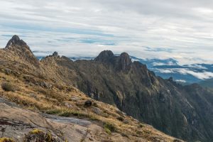
Rafael says we are close to the top, so we push on with new energy, winding our way in and out of the arête. After five hours of walking, we see Mount Wilhelm, a 100-foot-high knob sitting at the apex of several ridges. A small wooden frame marks the highest point.
A crowd of people cluster in the cold gale force wind, some of them waiting two hours for the Easter sunrise. We join them just in time to see the sun pop up over the Pacific, except we cannot see the Pacific as there are too many clouds!
The bank of clouds that lies about a half mile below us, blocking the view of the surface. We can see the lights of Madang and Mount. Hagen glowing through the clouds. About 20 mountain peaks puncture the cloud layer representing all the highest peaks in Papua New Guinea from the Owen Stanley’s, the Mueller Range, the Finisterre and the Saruwaged.
The return trip is magnificent. The warming sun now shows us what we missed in the dark. The glacial features stretch out like a map below us. The tundra vegetation grows a few inches higher than it does in the Rockies. Wildflowers, a few herbaceous plants and shrubs dominate. The cliffs that we edged across in the dark now seem more formidable. We are more careful climbing down. Chris’s knees give him a problem and we progress slowly giving me time to take photographs.
Along a narrow cliff we crawl over a rock cairn that covers the body of a Southern Highlander who died on the trail last year. A plaque embedded in a rock wall tells us where an Australian Sergeant took a wrong turn 20 years ago and was never seen again. Rafael shows us where an Israeli youth fell to his death. The metal from a World War II plane crash lies scattered over a square kilometer of mountain side.
The walk back to the hut takes us five hours, a good knee preserving pace. The vegetation gradually becomes thicker and taller. More tundra species begin to appear, small trees at 11,000 feet. Rafael cuts one to make a walking stick.
The other climbers are waiting for us at the hut, and they are ready for the walk down to the guest house. The three of us decide to eat something and rest for 2 hours while the others go on.
We sleep well that night at the guest house and the drive back to Lae is uneventful except for two near accidents when an oncoming truck moves into our lane and a pig walks in front of one of the vehicles. Rafael returns with us to Lae with its heat, slums, traffic, and rascals…….so unfitting for this mountain man.
